
 German

Initiative: “Sensor-Based Urban Green Space Maintenance”
Urban green spaces are crucial for the climate, the environment, and the quality of life in the city. However, due to climate change as well as increasing urban densification and land sealing, it is becoming increasingly difficult to preserve existing green spaces while also developing them in a resource-efficient manner. Droughts and heat waves are increasingly taking their toll on urban flora, and traditional irrigation methods often reach their limits due to blanket watering practices. Digital technologies are therefore intended to help improve the situation in a sustainable manner.
Establishment of a citywide sensor network for measuring soil moisture
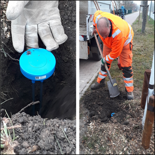
Sensors for measuring soil moisture will be installed at various depths at selected tree locations. The sensor data is intended to provide information about the actual water content in the soil and its changes over time, thereby ultimately making it possible to estimate the actual water requirements of the trees at each location. Since not every tree can be equipped with sensors, reference areas are established to group similar tree locations together. Up to three sensors are then installed at various depths per reference area. The sensors are LoRaWAN sensors that transmit their data wirelessly via the city’s comprehensive LoRaWAN network.
Utilization of Sensor Data for Urban Green Space Maintenance and Public Access
The soil moisture data collected is firststoredinthe city’sexisting databasesand then retrieved and visualized via the city’s urban data platform. The goal is to process the data in such a way that the city’s green space maintenance department can adjust its watering schedules as needed, potentially resulting in savings in terms of water usage, watering time, and travel distances. Urban green spaces are a shared responsibility, which is why the sensor data will also be made available to the public, e.g., as a traffic-light system on a map based on the city’s tree registry.
- Current Status
-
- Start: December 17, 2021
- End: August 31, 2027
- Status: In progress
- Milestones Achieved
-
- Various test sensors have been put into operation; data can be retrieved and visualized on an interim basis
- After the test phase, the sensor type for the application will be determined
- A local LoRaWAN network for the sensors has been set up and is being continuously expanded
- An external network server that manages the sensor data has been set up
- Reference areas and sensor locations have been defined for an initial city district
- 40 sensor locations, each with 2 measurement depths, have been set up
- The sensor data has been integrated into the Urban Data Platform (UDP)
- A dashboard for data visualization has been created